File:FronterasDeBulgariaSegúnSanStefanoYBerlín1878.svg
Jump to navigation
Jump to search


Size of this PNG preview of this SVG file: 773 × 600 pixels. Other resolutions: 309 × 240 pixels | 619 × 480 pixels | 990 × 768 pixels | 1,280 × 993 pixels | 2,560 × 1,986 pixels | 781 × 606 pixels.
Original file (SVG file, nominally 781 × 606 pixels, file size: 936 KB)
Captions
Add a one-line explanation of what this file represents
Captions
Summary[edit]
| Description |
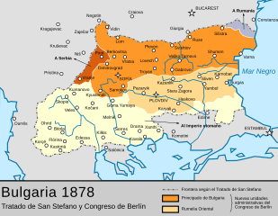
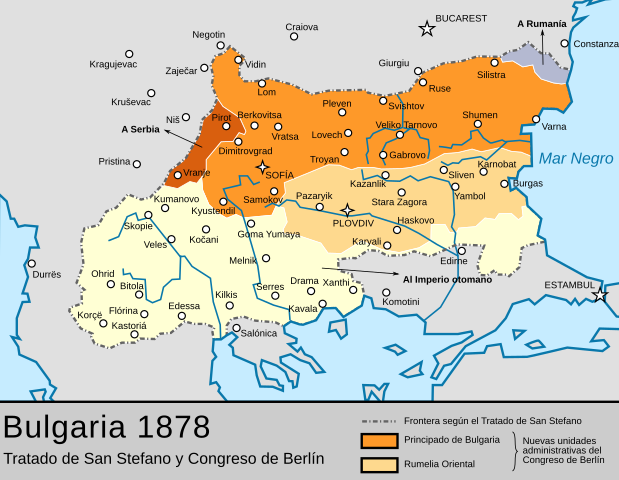
Español: Las fronteras de Bulgaria según el Tratado de San Stefano entre Rusia y el Imperio otomano y su correción por el posterior Congreso de Berlín, que creó el Principado de Bulgaria, autónomo dentro del Imperio, y la región semiautónoma de Rumelia Oriental dejando el resto de territorios en el Imperio. |
| Date | 20 September 2010, 22:36 (UTC) |
| Source | |
| Author |
|
| This is a retouched picture, which means that it has been digitally altered from its original version. Modifications: turned into SVG and Spanish. The original can be viewed here: Bulgaria-SanStefano -(1878)-byTodorBozhinov.png:
|

|
This SVG file contains embedded text that can be translated into your language, using any capable SVG editor, text editor or the SVG Translate tool. For more information see: About translating SVG files. |
Licensing[edit]
|
This file is licensed under the Creative Commons Attribution-Share Alike 3.0 Unported license. | |
|
Original upload log[edit]
This image is a derivative work of the following images:
- File:Bulgaria-SanStefano_-(1878)-byTodorBozhinov.png licensed with Cc-by-sa-3.0-migrated, GFDL
- 2010-01-04T11:24:37Z TodorBozhinov 786x613 (235372 Bytes) changed map name due to complaints that it's POV
- 2008-10-22T11:31:04Z TodorBozhinov 786x613 (241715 Bytes) please, reupload your edits of this version under a different name
- 2008-10-20T07:08:28Z Pruxo 786x613 (151688 Bytes) diferencia de colores
- 2006-02-17T16:12:31Z Martyr 786x613 (241715 Bytes) made darker, I discovered my monitor shows the colours somewhat dark and the image's actual colours are too light.
- 2006-01-26T14:37:52Z Martyr 786x613 (234573 Bytes) Ruse inscription was somehow erased
- 2006-01-23T22:28:20Z Martyr 786x613 (234298 Bytes) "Principality of Bulgaria" and "Eastern Rumelia" inscriptions fixed, they were somehow partly deleted.
- 2006-01-04T23:28:43Z Martyr 786x613 (230624 Bytes) correction in the northeast - the piece of Dobruja that was part of San Stefano Bulgaria but was given to Romania after the Congress of Berlin now marked.
- 2006-01-04T23:11:56Z Martyr 786x613 (230095 Bytes) "Vranja" to "Vranje (Vranya)" - Vranje is the correct contemporary Serbian name, Vranya is a transliteration of the Bulgarian one.
- 2006-01-04T19:18:30Z Martyr 786x613 (231126 Bytes) fixed wrong western border with Serbia, Pirot and Vranja were Bulgarian territory according to the Treaty of San Stefano
- 2006-01-01T21:21:40Z Martyr 786x613 (233421 Bytes) A map of liberated [[:en:Bulgaria|Bulgaria]] (1878) - borders after the [[:en:Treaty of San Stefano|Treaty of San Stefano]] (3 March 1878) and the [[:en:Congress of Berlin|Congress of Berlin]] (June 1878). Drawn by [[:en:Use
Uploaded with derivativeFX
File history
Click on a date/time to view the file as it appeared at that time.
| Date/Time | Thumbnail | Dimensions | User | Comment | |
|---|---|---|---|---|---|
| current | 11:25, 5 November 2016 | | 781 × 606 (936 KB) | Rowanwindwhistler (talk | contribs) | Dobruja added. Distribution of territories after the Berlin Congress added |
| 19:15, 31 October 2016 |  | 781 × 606 (659 KB) | Rowanwindwhistler (talk | contribs) | https://en.wikipedia.org/wiki/Wikipedia:WikiProject_Maps/Conventions http://colorbrewer2.org/#type=sequential&scheme=YlOrBr&n=5 Fake text added | |
| 15:02, 23 July 2011 |  | 781 × 606 (79 KB) | Ras67 (talk | contribs) | cropped, font rendering fixed | |
| 22:37, 20 September 2010 |  | 788 × 615 (141 KB) | Rowanwindwhistler (talk | contribs) | {{Information |Description={{es|1=Las fronteras de Bulgaria según el Tratado de San Stefano entre Rusia y el Imperio otomano y su correción por el posterior Congreso de Berlín, que creó el Principado de Bulgaria, autónomo dentro del Imperio, y la reg |
You cannot overwrite this file.
File usage on Commons
The following page uses this file:
File usage on other wikis
The following other wikis use this file:
- Usage on ast.wikipedia.org
- Usage on ca.wikipedia.org
- Usage on de.wikipedia.org
- Usage on en.wikipedia.org
- Usage on es.wikipedia.org
- Usage on fr.wikipedia.org
- Usage on gl.wikipedia.org
- Usage on it.wikipedia.org
- Usage on pt.wikipedia.org